Field Report on Cameraman's "Crash Site"
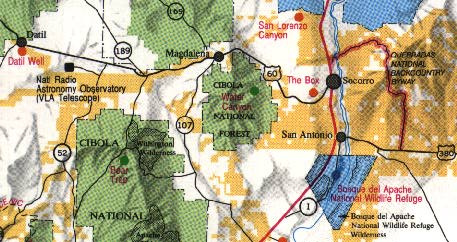
In a talk at BUFORA's UFO Conference in Sheffield on Aug 20, Michael Hesemann claimed to have found the crash site associated with Roswell autopsy film. This is the site the cameraman said he visited in 1947 to photograph flying saucer crash debris and where the alleged alien bodies were found. According to Hesemann, the cameraman says the crash site is near a dry lake somewhere south of the road from Socorro to Magdalena, New Mexico. This is about 150 miles west-northwest of Roswell but it could be seen as consistant with a multiple-crash-site theory or debris scattered over a wide area before the main craft came down. Hesemann says he followed the instructions given to him by Ray Santilli, who is the only public spokesman for the alleged cameraman. On the highway from Socorro to Magdalena, Hesemann turned south on a dirt road about 8 miles out of Socorro. About five miles down this road, Hesemann says he found a small dry lake about 200-300 meters across and shaped like the figure "8". Hesemann says the lake is near a "gateway" or cleft in the rocks. At this lake he says he found a discolored area that he feels deserves further study as a possible crash site.
On Sept. 17, armed with details from Hesemann posted to the net by George Wingfield (momus@cix.compulink.co.uk), who was at the BUFORA conference, I took an afternoon to follow these instructions and study the area. Indeed, the instructions were accurate, and I did find a small "dry lake," shaped like the number "8" near a gateway in the rocks. [drysite1.jpg]. However the term "dry lake" makes me uncomfortable, as there appear to be no natural dry lakes in this area. What I found was "dry" and a repository for water, but an American familiar with the West would use a different term. What I found was a cattle watering hole or reservoir. Here a drainage basin had been dammed by earthen dikes about six feet high to collect the run-off for watering cattle. The concept of a dry lake in this area seems alien to the geography, which is too well drained. If indeed the cameraman used this term, it suggests the possiblity that he had never really been to the area.
In detail, here is what I found....
Highway US-60 runs 26 miles from Socorro to Magdalena. This is the only road between these two towns, and presumably it dates to long before 1947. There are very few roads south from this highway, and all of them on the half approaching Magdalena dead- end in the nearby Magdalena Mountains (Cibola National Forest) before any basin is reached. There are only two through-roads south: maintained dirt roads at about 6 and 7 miles from Socorro respectively (mile markers 132.5 and 131.6). There are simply no other roads that could lead to any kind of basin; all the others lead up-slope into canyons or mountains.
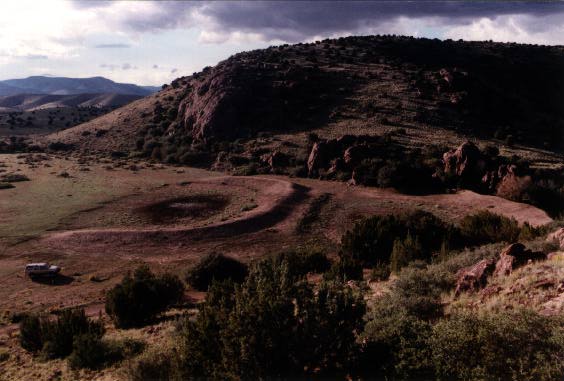
The road at milepoint 132.5 seems to close to Soccoro to match the description, while the one at 131.6 matched Hesemann's description and lead just where he said it would. This is a good road that any car should be able to handle except in wet weather. At the fork 0.4 from the highway, I went right; at 1.8, I went left. (Other routes lead to dead-ends or into mountains.) At 3.4 miles from the highway, I found it! Two adjacent cattle reservoirs appearing like the figure "8". This is in a scenic hollow which matches Hesemann's gateway-in-the-rocks description. The two reservoirs were in line with the drainage basis, apparently so the lower one would catch any overflow from the upper. Both were "dry" or more precisely thick mud churned by cattle hooves, and each was no more than 100 yards across. There were a lot of cattle tracks here, and there were also numerous car tracks. (They could have been from several cars or one car going back and forth; recent rains had obliterated the tread.) I found no sign of any discolored area except around an old salt trough where the cattle had gathered. [Photo, 28k] All the basin areas were all pretty trampled from the cattle and no surface traces would have remained there of an event almost 50 years ago (although the surrounding slopes might have been untouched). There was no way to be sure whether the reservoir had been in existence since 1947, but this is plausible since ranching has a long tradition in this area. The only thing of obvious interest in the area were some cattle bones.
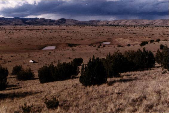
Because there had been a suggestion that the crash site might have been as much as ten miles south of the highway, I continued south for about 11.7 miles until I reached the Bianci Ranch, where the main road turns back to the east to the Rio Grande and Interstate 25. Enroute, I found another "8"-shaped reservoir, 6.6 miles from highway. [Photo, 44k] This one was somewhat larger, had water in it and showed no obvious car tracks off the road.
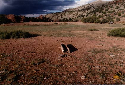
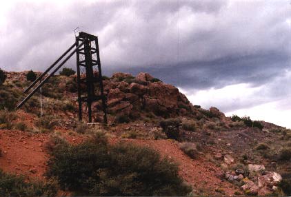
Returning to the first reservoir, I drove an unmaintained road downslope from the reservoir (through the "gateway") and found the remains of a significant mining operation, carving out a large part of a mountainside just out of view from the reservoir (about 1/4 mile). [Photo of some equipment, 28k] The state of decay of the equipment suggested that this mine could have been in operation in 1947--which would make this reservoir not remote at all from possible human witnesses.
Although this area is "desert", it is a relatively lush one with evidence of significant rainfall. The ravines are deeply eroded, and the cattle reservoirs show signs of frequent maintenance-- newly deposited stones to repair the erosion of the overflow channels. Without active maintenance, the earthen dams would probably be too eroded to be useful after a few years. The terrain in this area covers a relative abrupt downward slope from the highlands at Magdalena (elevation about 6500 feet) to the Rio Grande basin (about 4500 feet). Given the rainfall and slope, this is not any area conducive to dry lakes, where run-off pools in a wide basinand then evaporates. A Magdalena resident also reports that he knows of no dry lakes in the area.
Remaining Research: I did not explore the other road south from US-60, which the map says runs about 4 miles south before turning east toward the Rio Grande. I also did not explore roads south from the vicinity of the Bianchi Ranch. Since there was no hint of the kind of terrain that would support dry lakes, it did not seem productive to look further at this point. This region remains an interesting candidate, perhaps consistant with debris being spread out over a wide area west of Roswell. This area is rich in other UFO crash and landing lore, including the Lonnie Zamora sighting in Socorro and claimed crashes associated with Roswell on the Plains of San Augustin.
Speculation: To someone living far away and looking only at maps, all deserts may seem the same, but there are many different kinds of desert terrain, and you often have to visit the area to know which description applies. If the cameraman actually used the term "dry lake," this seems inappropriate. Could the cameraman have chosen this area based on the UFO literature without actually visiting it? Hesemann might then have settled on this specific site as the only one that remotely matched?
GPS Coordinates....
                                    Latitude     Longitude
  US-60: Socorro, at Highway NM-1   34d03.219'   106d53.458'
  US-60: Road south at MP 132.5     34d00.263'   105d58.534'
  US-60: Road south at MP 131.6     34d00.469'   106d59.495'
    First reservoir (dry) 3.4mi     33d58.279'   106d59.558'
    Second reservoir (wet) 6.6mi    33d55.812'   107d00.598'
Other Photos...
Later: Bob Shell offers new crash site west of Magdelana, 3/1/96