10 GPS Vulnerabilities
by Lieutenant Colonel Thomas K. Adams, US Army, Retired
For centuries explorers have navigated by fixed stars. Today our
increasingly expeditionary military navigates by orbiting emitters. Satellites
enable flexible communication and precise navigation that were unimaginable
a generation ago. Space-based technologies reach down into everyday military
business so much that interrupted service immediately and fundamentally
degrades operations. Adams describes various threats to US satellites,
systems that use their signals and a military that depends on falling stars.
The US Armed
Forces' 21st-century combat plan is based on Joint Vision 2020, an extension
of Joint Vision 2010's conceptual template that is reflected in the US
Army Chief of Staff's Army Transformation Program, the Marine Corps' Sea
Dragon programs and various service statements, policies and other implementing
plans. All of these are part of a seminal effort to leverage information-age
technologies in a lethal, agile and rapidly deployable 21st-century force.1
Equally, they all depend heavily on information technology and space-based
capabilities.
Joint Vision 2010 states the need for "space and information superiority
. . . to accomplish the assigned tasks."2 The same philosophy
is reflected in various posture statements and other service-peculiar policy
documents. In his recent posture statement before Congress, General Henry
H. Shelton, Chairman, Joint Chiefs of Staff, repeatedly referred to the
importance of space-based technologies and information for the US Armed
Forces.3
The vision statements, implementing programs and policy statements are
built on two foundation blocksinformation systems and space-based resources.
Together they lead to the "information dominance" that is key to the entire
enterprise.4 Unfortunately, the inescapable interrelationship
between the two creates serious vulnerabilities that could destroy military
forces.
A Double-Edged Sword
Like most recent force-modernization efforts, most of Army After Next
(AAN) and Army XXI technologies will come from commercial-sector research
rather than Department of Defense (DOD)-sponsored research and development.
Major General Robert Scales, a key architect of the AAN program, says about
40 percent of the dollars spent 25 years ago on telecommunications research
and development came from DOD. In Fiscal Year 2000, DOD provided about
2 percent of the funds spent on developing information-age technologies.5
During
a National Defense Industrial Association conference on the future force,
Scales remarked, "Like it or not, the advantage we are going to gain in
the future over a potential major competitor is going to come from the
commercial sector. We ought to just step back, relax and be prepared to
exploit it. In many ways, too much emphasis on military specific research
. . . may very well work to our disadvantage."6
Dual use is not a ground-breaking innovation; it is a long-term trend.
The United States has never owned a freestanding, solely military industrial
base. Most military equipment is off-the-shelf commercial equipment painted
olive drab. The American Expeditionary Force took commercial trucks right
off the assembly line to France in 1917. The famous C-47 World War II transport
aircraft was a green-painted cargo version of the Douglas DC-3 airliner.
Artillery officers discovered hand-held Hewlett-Packard calculators early
on, but the first widely distributed small computers in the US Army were
ordinary Apple IIe's in a "militarized" box. The best-known example is
probably the military use of thousands of off-the-shelf commercial Grid
Positioning System receivers during the Gulf War.
DOD directed research and development in areas of particular defense
interest until about 1965. Since then, especially after the Cold War, the
trend has accelerated away from DOD-led research.7
Dual Use and Vulnerabilities
Before entering the 21st century dependent on space-based systems and
commercially developed information-technology based systems, the US military
must understand its capabilities, limitations and vulnerabilities. Dual-use
and off-the-shelf technologies offer real advantages and are especially
cost effective. However, they have serious disadvantages:
-
Dual use means that both civilian and military users employ the same technology.
Technology training, documentation and product improvements are also available
to potential adversaries.
-
Off-the-shelf merchandise provides civilian and military users with nearly
identical systems. Systems designed to operate in a much less stringent
peacetime environment could be chosen rather than those designed for combat.
-
States, political movements and individuals can obtain current military
technology without costly research, development, manufacture, training
capacity or espionage.
Dual-use and off-the-shelf policies can give various entities much of the
military capacity formerly reserved to the great powers.
A Case Study
Built at a cost of $21 billion, the Global Positioning System (GPS)
consists of an orbiting constellation of small artificial satellites, called
NAV-STAR, which give receivers accurate altitude and geographic positioning
information. Originally, the system was to be exclusively military, but
in 1980, the US government transformed it into a free, globally available
system. The system is now undergoing a long-term, billion-dollar improvement
and upgrade.8
During the Gulf War, GPS gave a major advantage to coalition forces,
allowing tanks and aircraft to navigate Iraq's unmarked deserts. GPS was
an unqualified success and quickly became central to a revolution in military
affairs. Most US military aircraft now use GPS, and the US Army uses almost
100,000 GPS units. Eventually, every major precision-guided munition will
target using GPS navigation.9 In addition to combat uses, the
US military uses GPS for routine activities ranging from surveying and
civil engineering to base infrastructure applications.
GPS, which provides accurate positioning to within 100 meters, is free
to anyone with a receiver, including actual and potential US adversaries.
For instance, on 1 March 2000, Iran Aircraft Manufacturing Industries announced
that two new variants of its Ababil unmanned air vehicle will use on-board
GPS navigation.
Dual use includes technologies that both military forces and civilians
can use. This US Air Force investment (plus $600 million in annual operating
expenses) is used for tracking commercial trucking and airline and merchant
marine navigation. Commercial aviation and private pilotsincluding drug
smugglersuse the GPS Standard Positioning Service. The US Federal Aviation
Administration (FAA) and its Canadian counterpart are also planning to
use GPS throughout the North American Air Traffic Control System using
the Wide Area Augmentation System, a GPS system with 1- to 3-meter accuracy.
Since the FAA also intends to broadcast GPS corrections via geostationary
satellites, worldwide airlines will likely take advantage of this highly
accurate system for normal en route navigation, collision avoidance and
airport ground navigation.. In fact, the FAA would like to make GPS the
only navigation system for commercial air traffic.10
Despite this, the United States and its allies had hoped to retain access
to 10-meter accuracy through selective availability encoding, also known
as the Precision Positioning Service. This navigational edge was expected
to help the US military conduct 21st-century warfare.11 President
William J. Clinton directed that selective availability be discontinued
at midnight Eastern Daylight Time 1 May 2000, removing our navigational
edge. According to a White House press release issued the same day, discontinuing
use of selective availability would improve the GPS accuracy for civilian
users from within 100 meters (about 300 feet) to within 20 meters (about
60 feet). In many cases, real-world users realized even better accuracy.
This performance boost enabled GPS to serve various civilian activitiesland,
sea, air and spacewhere it previously could not.
This effect offers highly accurate GPS positioning to anyone who wants
to use it for military purposes. For example, an ordinary executive-class
jet with an automatic pilot slewed to GPS signals can become a rudimentary
long-range cruise missile simply by filling the interior with explosives
and an impact detonator and sending it to its target. Improved GPS would
ensure that the missile would strike within 20 meters of the desired point.
In theory, GPS could still give the United States and its allies a navigational
advantage by preserving an ability to "tweak," or adjust, GPS signals to
focus the effect on adversaries without adversely affecting friendly forces.12
Adjusting signals is always problematic since the "local area" is likely
to be large, and any tweaking is likely to affect friendly military GPS
near the target area as well as enemy ones. In any case, it would be dangerous
to exercise this capability since it could also affect unin-volved civilian
traffic such as ships or airlines.
The National Academy of Science and the National Academy of Public Administration
are advancing the concept of internationalism, calling GPS an emerging
de facto international utility. This notion only complicates the situation
because the idea of serving as a utility assumes some obligation to assure
service to users. Furthermore, upgraded GPS performance is expected to
accelerate its worldwide business, government and individual use. Signal
tweaking would likely raise protests from many civilian users.
InterferenceIntentional and Otherwise
Jamming is quite simple, both in principle and in practice. Almost anyone
who is interested can do it. Jamming only becomes difficult when the user
wants to limit the effect to a narrow, specific range of frequencies over
a great distance. Such a power and focus is important to high-tech users
who depend on their own electronic systems. A less sophisticated user who
wishes only to deny an adversary's capability has no reason for concern.
Careful planning could allow a low-tech adversary to conduct electronic
countermeasuressuch as jammingand wreak havoc on a high-tech opponent
while the low-tech force uses relatively crude electronics such as frequency-modulated
radios at short ranges.
The Defense Science Board and the National Research Council confirm
that GPS jamming poses a real threat.13 David E. Lewis, Magnavox
Electronic Systems Company, quoted the Defense Science Board's November
1993 Tactical Air Warfare study, "Current GPS receivers are vulnerable
to jamming in acquisition mode at very long ranges from low-power jammers
and will lose track at moderate range for reasonable jammer threats."14
Lewis states that a 100-watt jammer can affect a standard military GPS
receiver, such as a precision-guided munition would carry, as far away
as 600 miles (or line-of-sight distance, whichever is less) during initial
GPS acquisition. Even when the missile has acquired the GPS signal and
is using it to track its progress to the target, such tracking could be
interrupted within 28 miles of the jammer.
Commercial television, very high-frequency transmitters, aeronautical
satellite communications and Mobile Satellite System terminals can also
degrade GPS signals, and natural occurrences can cause interference that
would pose distinct problems for users, including the military.15
Designers were aware that GPS signal interference was possible but faced
a basic problemplacing weight in orbit is costly. To reduce costs and
extend operating life, GPS satellites were designed to produce weak signals;
only a few milliwatts. The decision makes good engineering sense but, unfortunately,
makes GPS signals easy to jam.
Former Assistant Deputy Undersecretary of Defense for Strategic Aeronautical
and Theater Nuclear Systems, Dr. Stanley B. Alterman, stated that a 1-watt
(cellular phone-size) jammer located 60 kilometers away (line of sight)
can prevent a good commercial GPS receiver from acquiring Navigation Satellite
Timing and Ranging (NAVSTAR) signals. Well-designed military receivers
are, to some degree, jam resistant because jamming them would require a
100-watt jammer to disrupt it from 20 kilometers away.16 However,
jammers are inexpensive and simple to build, and even a large, crude one
can fit comfortably in a pickup truck. Expendable hockey puck-size jammers
already exist and can be scattered from aircraft.
 On
the "fragile battlefield" of the future, GPS-dependent operations could
be adversely affected by diminutive jammers scattered by helicopters, UAVs,
aircraft and easily manufactured mine-scattering devices similar to the
US Army's ground-emplacement mine-scattering system (above). A number
of inexpensive jammer/spoofers, orbiting in cheap UAVs over a "digitized"
force, could randomly degrade operations.
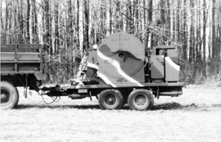
On
the "fragile battlefield" of the future, GPS-dependent operations could
be adversely affected by diminutive jammers scattered by helicopters, UAVs,
aircraft and easily manufactured mine-scattering devices similar to the
US Army's ground-emplacement mine-scattering system (above). A number
of inexpensive jammer/spoofers, orbiting in cheap UAVs over a "digitized"
force, could randomly degrade operations.
Hugh Blanchard suggests that a GPS jammer/spoofer that can render GPS
receivers inaccurate within a 10-mile radius can be built for less than
$400 from parts available at retail stores. A number of inexpensive jammer/spoofers,
orbiting in cheap unmanned aerial vehicles (UAVs) over a "digitized" force,
could randomly make US self-location and force-tracking capabilities unreliable.
Blanchard adds that placing such devices throughout probable target areas
would enable an enemy to misguide US precision-guided weapons aimed at
enemy centers of gravity. This would certainly create a ripple effect through
the Army, causing confusion, fratricide, hits on unintended targets and
civilian casualties.17
This results in what Alterman refers to as a "fragile battlefield" where
GPS-dependent operations could be easily stymied. Developing affordable
anti-jamming concepts such as nulling antennas and cancellation electronics
would counter threats. Alterman further explains that future electronic
combat will also require "GPS jammer location and targeting systems, as
well as our own GPS jammers (howitzer-launched or mounted on UAVs or helicopters)."
He urges improvements in "GPS designs for signal acquisition, an ability
for weapons systems to lock-on before launch and low-cost Inertial Navigation
System integration. Auxiliary terminal sensors and even battlefield pseudolite
augmentation must be strongly considered in jamming scenarios."18
The military cannot meet key requirements to improve resistance to intentional
and unintentional interference (including a higher-power GPS signal) until
currently planned Block III satellites are in orbit sometime after 2010.
Unfortunately, it is much easier to increase an earth-bound jammer's output
than it is to raise an orbiting transmitter's designed signal strength.
Falling Stars
The electronic details of GPS are completely irrelevant unless the satellites
remain in orbit. The National Reconnaissance Office convened a futures
study panel that found "the future security of the nation depends on its
ability to conduct surveillance from space."19 That space got
a little more crowded on Monday, 31 August 1998. According to the Harvard-Smithsonian
Center for Astrophysics, North Korea launched a satellite that failed to
enter orbit when the rocket's third stage malfunctioned. During the same
month three highly sophisticated vehicles from "major powers" launch failures.
North Korea's launcher was apparently cobbled together from a Nodong
2 missile as the first stage with an adapted Scud as the second stage.
The third (orbital) stage was probably a small solid motor. This Rube Goldberg
contraption narrowly missed placing North Korea among the space powers.
North Korea media called the satellite "one more fruit of the independent
national economy, a product of 100 percent local technology and local effort."20
While the purity of this pedigree is doubtful, the consequences of the
feat are not.
A satellite could bring North Korea much closer to sending payloads
into orbit for reconnaissance, communications and navigation. These nice-to-have
capabilities are not crucial to North Korea's terrestrial aspirations.
Such a satellite could offer the ability to launch crude attacks on satellite
systems.
Space-based systems are militarily important to the United States for
all large-scale operations. The US philosophy has been to orbit a few very
expensive (up to $1.2 billion each) satellites with longevity and maximum
capability. US military operations depend increasingly on a few, very expensive,
difficult-to-replace orbiting systems, making it unlikely that there are
many "orbiting spares."
 Ordinary
meteorological sounding rockets routinely carry 50- to 100-pound payloads.
A rocket carrying 40 pounds of 00 steel buckshotavailable in most sporting
goods storescould kick the pellets out into an appropriate orbit with
an explosive charge. Moving at relative velocities of about four miles
a second, the tiny pellets would slam into and disable any satellite they
encountered. The Soviet Union successfully tested this concept in a more
elaborate form and produced an operational version in the early 1980s.
Illustration from Soviet Military Power, 1983.
Ordinary
meteorological sounding rockets routinely carry 50- to 100-pound payloads.
A rocket carrying 40 pounds of 00 steel buckshotavailable in most sporting
goods storescould kick the pellets out into an appropriate orbit with
an explosive charge. Moving at relative velocities of about four miles
a second, the tiny pellets would slam into and disable any satellite they
encountered. The Soviet Union successfully tested this concept in a more
elaborate form and produced an operational version in the early 1980s.
Illustration from Soviet Military Power, 1983.
Any US adversary could place a crude antisat-ellite system in orbit
relatively cheaply. A US reply in kind is impossible because the belligerent
would not have any significant orbiting systems or related ground-based
infrastructure. It is impossible to take out their "eyes in the sky" because
they do not have any.
The US Space Command currently does not have an operational antisatellite
weapon. Other powers can because they are not hamstrung by international
legal issues and do not need sophisticated, discriminating weapons.21
It is not difficult to reach at least low-earth orbit with ordinary meteorological
sounding rockets that carry 50- to 100-pound payloads.22 If
a rocket could carry 40 pounds of 00 steel buckshotavailable in most sporting
goods storesit could kick the pellets out into an appropriate orbit with
an explosive charge. Moving at relative velocities of about four miles
a second, the tiny pellets would slam into and disable any satellite they
encountered.23
If an attacker wonders where to find such satellites, help is available.
Off-the-shelf telescopes, sensors and software, including computer-directed
telescopes, are now so cheap and powerful that amateur skywatchers can,
and do, track and photograph orbiting spacecraft, including a number of
US scientific, military and intelligence-gathering vehicles.24
Defending the Indefensible
Can an orbiting satellite be protected? Some already are. Satellites
can be hardened (armored) or enhanced to maneuver away from attacks. Unfortunately,
armor adds weight and degrades satellite capability. The space shuttle
has been used to launch satellites, but it is slow, public, extremely expensive
and vulnerable. Some satellite parts, such as the solar panels on the GPS
birds, cannot be armored. Perhaps adding more maneuvering fuel could allow
detection of attacks in time to move the target. This raises the weight-versus-capability
issue again and also means the satellite would be useless while it is out
of its assigned orbit.
The effectiveness of these defense measures is limited; an attacker
could increase his satellite lethal-ity simply by using ball bearings instead
of buckshot and attacking twice. Suppose the attacker has a little better
lift capacity and is less fussy. Orbiting a thousand pounds of gravel could
sweep parts of near-Earth space like a broom and provide history's most
spectacular meteor shower as millions of tiny rocks, bits of $500-million
satellites and plans for information dominance all begin the long slide
to earth.25
Of the options being explored, the best defense method against such
an attack is probably to orbit dormant spares that can be activated when
needed. Of course the spares would still be expensive, complicated and
relatively inexpensive to defeat.
The time needed for countries such as China, India, Japan or North Korea
to acquire significant space-denial capabilities is rapidly becoming less
than the time the United States needs to replace existing satellites. During
the Falklands War, the Soviet Union launched 29 small satellites within
69 days. In contrast, the United States took 113 days to replace a defense
weather satellite after an emergency.26
A practical solution can possibly be found in a proposal now under study
to use small-size, optico-electronic, radar and electronic reconnaissance
satellites that can be quickly manufactured and launched by light booster
rockets during crises. These satellites will conduct reconnaissance with
worse resolution than current methods. However, this is only a partial
solution since it does not solve the problem of other satellites used for
communications and navigation.27 Whatever their ultimate form,
solutions to space vulnerabilities must enable the US military's information
dominance.
1.The Joint Chiefs of Staff, Joint Vision 2020 (Washington, DC:
US Government Printing Office, June 2000), 1; and Department of the Army,
"Army Releases Army Vision 2010" (Washington, DC: Office of the Chief,
Public Affairs, 15 November 1996).
2.Ibid., 23; and Avery V. Allison Jr., "The State of the US Army and
Space Operations," Strategy Research Project, US Army War College, Carlisle
Barracks, PA, 1998.
3.GEN Henry H. Shelton, "Posture Statement of General Henry H. Shelton,
USA, Chairman of the Joint Chiefs of Staff Before the 106th Congress
Committee on Armed Services, United States Senate, 8 February 2000," <www.dtic.mil/jcs/core/Posture00.html>;
and MAJ Henry G. Franke, "An Evolving Joint Space Campaign and the Army's
Role" (Fort Leavenworth, KS: US Army Command and General Staff College,
School of Advanced Military Studies, 1996), 77-78.
4.Joint Vision 2020, 10-11; and Defense Science Board, Report
of the Defense Science Board Task Force on Information WarfareDefense
(IW-D) (Washington, DC: US Department of Defense, Office of the Under
Secretary of Defense for Acquisition and Technology, November 1996), hereinafter
referred to as IW-D.
5.MG Robert Scales' remarks are courtesy of the US Army War College
Public Affairs Office, Carlisle Barracks, PA, June 2000.
6.Ibid.
7.Michael Hirsh, "The Great Technology Giveaway?" Foreign Affairs
(September/October
1998), 2-9 and 3.
8.Elliott D. Kaplan, ed., Understanding GPS: Principles and Applications
(Boston: Artech House, 1996); and Alfred Leick, GPS Satellite Surveying,
2d ed. (New York: John Wiley & Sons) 1995. An excellent presentation
by Peter H. Dana of the Department of Geography, University of Texas at
Austin, "Global Positioning System Overview," <www.colorado.edu/geography/gcraft/notes/gps/gps_f.html>.
9.Stanley B. Alterman, "GPS Dependence: A Fragile Vision for US Battlefield
Dominance," Journal of Electronic Defense (September 1995).
10.Ibid.
11.Stephen M. Hardy, "Will the GPS Lose Its Way?" Journal of Electronic
Defense (September 1995).
12.Alterman.
13.IW-D.
14.Hardy.
15.Ibid.
16.Alterman.
17.Hugh V. Blanchard, personal correspondence between the author, 2
November 1998. Blanchard is a retired US Army officer with an interagency
background in electronic warfare, electronic communications and data security.
18.Alterman.
19.National Reconnaissance Office, Final Report to the Director, "Defining
the Future of the NRO for the 21st Century," Executive Summary (Washington,
DC: National Reconnaissance Office, 26 August 1996), 1; and US Army Training
and Doctrine Command (TRADOC) Pamphlet 525-60, Operational Concept for
Space Support to Land Force Operations (Fort Monroe, VA: Headquarters,
TRADOC, 1 November 1994).
20.Comments from US sources imply that a third-stage burn was observed,
but nothing was spotted on radar, suggesting that the satellite fell into
the Pacific Ocean instead of reaching orbit; Personal correspondence from
Dr. Jonathan MacDowell, Harvard-Smithsonian Center for Astrophysics, Cambridge,
Massachusetts, 4 September 1998.
21.US Space Command, "U.S. Space Command" Brochure (Peterson Air Force
Base, CO: US Space Command, 1997), 11. The US Army Space Command controls
Army ballistic missile defense (BMD)/anti-satellite (ASAT) capability but
lacks operational systems. President William J. Clinton vetoed an Army
program to provide an emergency ASAT capacity with a kinetic energy anti-satellite
(KE-ASAT) that Boeing Space Systems was developing. See Bill Gertz, "Yeltsin
Letter Reveals Antisatellite Weapons," The Washington Times (7 November
1997). The nearest term US ASAT system is the existing mid-infrared advanced
chemical laser (MIRACL) located at White Sands Missile Range, New Mexico.
Originally a Strategic Defense Institute project, the laser is being adapted
to use against satellites. The former Soviet Union is also believed to
have constructed, tested and flown some ASAT devices in the late 1960s.
China does not have a publicly identified, dedicated ASAT effort. Existing
Chinese launch capabilities could provide the basis for rapidly developing
such a system. See Federation of American Scientists, "Space Defense,"
<www.fas.org/spp/military/program/asat/overview.htm>.
22.Harry G. Stien, Confrontation in Space (Englewood Cliffs,
NJ: Prentice-Hall, 1981), 82.
23.The Korea Aerospace Research Institute (KARI) has a sounding rocket
that reaches low-Earth orbit using the two-stage solid-fuel Keyboard Send/Receive-II
sounding rocket. The Anhueng launch site in Ch'ungch'ong Namdo province
has publicly announced four launches.
24.Leonard David, "New Software Enables Amateurs to Track Satellites,"
Space
News (August 1996), 8. A crude tracking program for nonmilitary satellites
is available at <www.liftoff.msfc.nasa.gov/RealTime/JTrack/>. NASA tracks
objects in near-Earth space that are larger than a few inches and has proposed
a system to track one-half inch objects at 18,000 to 23,000 miles.
25.Sounding rockets do not go into low-Earth orbit; they go to the same
altitudes as low-Earth orbits. Altitudes are quite different. Most sounding
rockets, such as South Korea's, cannot put anything into orbit, but they
can put something at zero velocity at low orbital altitudes such as an
explosive fragmentation device, which still has anti-satellite potential.
Gravel and ball bearings put into orbit are much more dangerous because
they stay there a few days and scrub the entire low-Earth orbit. Using
sounding rockets puts the material there for 10 minutes or so and wipes
out one specific satellite rather than everything in that orbit. Using
explosive charges to further propel the material, however, can add considerably
to this performance.
26.MAJ Jeffrey L. Caton, "We Can Reduce Satellite Vulnerability," Research
Paper (Maxwell Air Force Base, AL: Air University Press, 1994). Also interesting
in this connection is "Convergence of Space SectorsA New Symbiosis" an
address by General Howell M. Estes III, US Space Command, at the 1998 National
Space Symposium, Colorado Springs, CO, 9 April 1998.
27.Lt Col A. Andronov and Sr Lt R. Shevrov, "American Overhead Visual
Reconnaissance Systems" Zarubezhnoye Voyennoye Obozreniye (Foreign
Military Review) (1995), 37-42.
Lieutenant Colonel Thomas K. Adams, US Army, Retired, is involved
in military futures work for the US Army Special Operations Command, Fort
Bragg, North Carolina. He received a Ph.D. from Syracuse University, and
is a graduate of the National Strategy Course and the US Army Command and
General Staff College. He has written numerous articles on military-related
subjects as well as two books, US Special Operations Forces in Action
and
the forthcoming Post-Industrial Warfare. He has served in various
command and staff positions in the Continental United States, Vietnam and
Bosnia. As a special operations officer, his assignments ranged from counterinsurgency
to humanitarian assistance and counterdrug missions.
GPS Signals Jammed During Tank Trials
Lieutenant Colonel Lester W. Grau, US Army, Retired
Based on 6 August 2000 reports in The Sunday Times of London,
Agence France-Presse and the 25 September 2000 Elevtheros Tipos,
Athens
The highly accurate Global Positioning System (GPS) supports modern
ground forces as they move and shoot. Maps and compasses stay in cases
as digitized forces quickly use GPS to determine their location and the
enemy's. Although map-reading skills atrophy, few worry that GPS may suddenly
provide erroneous information or cease working. Still, US Army equipment
has already faced attacks on GPS functionsby allies.
In August 2000 the Greek government sponsored a tank competition at
Litokhoro to determine the Greek army's next tanka deal worth $1.4 billion
for 250 tanks. Competitors included the British Challenger 2E, the US M1A1
Abrams, the German Leopard 2A5 and the French Leclerc. During the trials,
the British and US tanks had navigation problems despite using multiple
GPS satellites to determine their positions precisely. After the embarrassing
performance, officials discovered that the GPS satellites were being jammedby
a French security agency. Less than a foot high, the jammers transmitted
stronger signals than satellites on the same frequency. The jammers were
reportedly hidden on the firing range and remotely activated as US and
British tanks were tested.
Greek defense officials found the jamming episode rather amusing and
discounted the associated technical problems. The threat remains: if an
ally can create such havoc during a test, what effect could hostile GPS
jamming have during combat?
Photos:
US Army
DOD