In order to understand how the GPS satellite system works, it is very helpful to understand the concept of trilateration.
|
|
Let's look at an example to see how trilateration works.
Let's say that you are somewhere in the United States and you are TOTALLY lost -- you don't have a clue where you are. You find a friendly-looking person and ask, "Where am I?" and the person says to you, "You are 625 miles from Boise, Idaho." This is a piece of information, but it is not really that useful by itself. You could be anywhere on a circle around Boise that has a radius of 625 miles, like this:
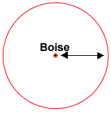 If you know you are 625 miles from Boise, you could be anywhere on this circle. |
So you ask another person, and he says, "You are 690 miles away from Minneapolis, Minnesota." This is helpful -- if you combine this information with the Boise information, you have two circles that intersect. You now know that you are at one of two points, but you don't know which one, like this:
 If you know you are 625 miles from Boise and 690 miles from Minneapolis, then you know you must be at one of two points. |
If a third person tells you that you are 615 miles from Tucson, Arizona, you can figure out which of the two points you are at:
|
With three known points, you can determine that your exact location is somewhere near Denver, Colorado! |
With three known points, you can see that you are near Denver, Colorado!
Trilateration is a basic geometric principle that allows you to find one location if you know its distance from other, already known locations. The geometry behind this is very easy to understand in two dimensional space.
This same concept works in three dimensional space as well, but you're dealing with spheres instead of circles. You also need four spheres instead of three circles to find your exact location. The heart of a GPS receiver is the ability to find the receiver's distance from four (or more) GPS satellites. Once it determines its distance from the four satellites, the receiver can calculate its exact location and altitude on Earth! If the receiver can only find three satellites, then it can use an imaginary sphere to represent the Earth and can give you location information but no altitude information.
For a GPS receiver to find your location, it has to determine two things:
- The location of at least three satellites above you
- The distance between you and each of those satellites
Measuring Distance
GPS
satellites send out radio
signals that your GPS receiver can detect. But how does
the signal let the receiver know how far away the satellite
is? The simple answer is: A GPS receiver measures the amount
of time it takes for the signal to travel from the satellite
to the receiver. Since we know how fast radio signals travel
-- they are electromagnetic waves and so (in a vacuum) travel
at the speed of light, about 186,000 miles per second -- we
can figure out how far they've traveled by figuring out how
long it took for them to arrive.
Measuring the time would be easy if you knew exactly what time the signal left the satellite and exactly what time it arrived at your receiver, and solving this problem is key to the Global Positioning System. One way to solve the problem would be to put extremely accurate and synchronized clocks in the satellites and the receivers. The satellite begins transmitting a long digital pattern, called a pseudo-random code, as part of its signal at a certain time, let's say midnight. The receiver begins running the same digital pattern, also exactly at midnight. When the satellite's signal reaches the receiver, its transmission of the pattern will lag a bit behind the receiver's playing of the pattern. The length of the delay is equal to the time of the signal's travel. The receiver multiplies this time by the speed of light to determine how far the signal traveled. If the signal traveled in a straight line, this distance would be the distance to the satellite.
The only way to implement a system like this would require a level of accuracy only found in atomic clocks. This is because the time measured in these calculations amounts to nanoseconds. To make a GPS using only synchronized clocks, you would need to have atomic clocks not only on all the satellites, but also in the receiver itself. Atomic clocks usually cost somewhere between $50,000 and $100,000, which makes them a little too expensive for everyday consumer use!
The Global Positioning System has a very effective solution to this problem -- a GPS receiver contains no atomic clock at all. It has a normal quartz clock. The receiver looks at all the signals it is receiving and uses calculations to find both the exact time and the exact location simultaneously. When you measure the distance to four located satellites, you can draw four spheres that all intersect at one point, as illustrated above. Four spheres of this sort will not intersect at one point if you've measured incorrectly. Since the receiver makes all of its time measurements, and therefore its distance measurements, using the clock it is equipped with, the distances will all be proportionally incorrect. The receiver can therefore easily calculate exactly what distance adjustment will cause the four spheres to intersect at one point. This allows it to adjust its clock to adjust its measure of distance. For this reason, a GPS receiver actually keeps extremely accurate time, on the order of the actual atomic clocks in the satellites!
One problem with this method is the measure of speed. As we saw earlier, electromagnetic signals travel through a vacuum at the speed of light. The Earth, of course, is not a vacuum, and its atmosphere slows the transmission of the signal according to the particular conditions at that atmospheric location, the angle at which the signal enters it, and so on. A GPS receiver guesses the actual speed of the signal using complex mathematical models of a wide range of atmospheric conditions. The satellites can also transmit additional information to the receiver.
From this discussion you have learned several important facts about the Global Positioning System:
- The Global Positioning System needs 24 operational satellites so it can guarantee that there are at least four of them above the horizon for any point on Earth at any time. In general, there are usually eight or so satellites "visible" to a GPS receiver at any given moment.
- Each satellite contains an atomic clock.
- The satellites send radio signals to GPS receivers so that the receivers can find out how far away each satellite is. Because the satellites are orbiting at a distance of 12,660 miles (20,370 km) overhead, the signals are fairly weak by the time they reach your receiver. That means you have to be outside in a fairly open area for your GPS receiver to work.
Finding the
Satellites
The other crucial component of GPS
calculations is the knowledge of where the satellites are.
This isn't difficult because the satellites travel in a very
high, and predictable orbits. The satellites are far enough
from the Earth (12,660 miles) that they are not affected by
our atmosphere. The GPS receiver simply stores an
almanac that tells it where every satellite should be
at any given time. Things like the pull of the moon and the
sun do change the satellites' orbits very slightly, but the
Department of Defense constantly monitors their exact
positions and transmits any adjustments to all GPS receivers
as part of the satellites' signals.
The most essential function of a GPS receiver is to pick up the transmissions of at least four satellites and combine the information in those transmissions with information in an electronic almanac, so that it can mathematically determine the receiver's position on Earth. The basic information a receiver provides, then, is the latitude, longitude and altitude (or some similar measurement) of its current position. Most receivers then combine this data with other information, such as maps, to make the receiver more user friendly. You can use maps stored in the receiver's memory, connect the receiver up to a computer that can hold more detailed maps in its memory or simply buy a detailed map of your area and find your way using the receiver's latitude and longitude readouts.
Geographers have mapped every corner of the Earth, so you can certainly find maps with the level of detail you desire. You can look at a GPS receiver as an extremely accurate way to get raw positional data, which can then can be applied to geographic information that has been accumulated over the years. GPS receivers are an excellent navigation tool, with seemingly endless applications!