This page contains map files for use in the position ploting system in WACARS. All of the maps are saved as 16 colour standard pallet BMP files. These are not complete, so feel free to e-mail me your additions.
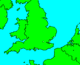
The default UK map. Covers from W6.58 to E2.64 and N49.85 to N53.44
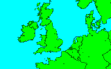
A slightly longer range UK map. Covers from W8 to E5 and N49 to N55
 [uk1.zip - MISSING]
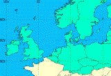
A map of northern Europe and the north east Atlantic. Covers from W15 to E15 and N48 to N60
Another map of Northern Europe. Covers from W11 to E21 and N45 to N65.
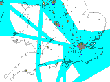
Sent in by Doris van der Veen, "is from Flightplanner 4.0, by M Meassen."
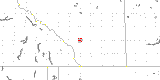
A map of Western Alberta produced by Tony Fletcher from Calgary. "The map takes in about 350 miles radius of Calgary N51.05000 W114.08300 and Lat and Log lines are on it.
 [alberta.zip - MISSING]
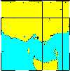
A map of Southern Australia, provided by Paul Proctor. It covers from from -34 to -42 south and 140 to 150 east.
 [sth.zip - MISSING]
A map for Montreal and Quebec area, provided by Francois Michaud-Herbst. It is not perfect (not the proper projection) it covers from 66 to 76 west and 45 to 50 north.
 [montreal.zip - MISSING]
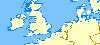
A map for Europe, provided by Ed Peters.
You can create your own maps
here.Introduction Screen Shots Installation Frequencies Databases Maps FAQ Links Download Registration